Latitude and Longitude Hide and Seek
On Monday, through a question and answer session, I determined what the students knew or thought they knew about latitude and longitude. I used a globe and asked about various lines - the equator, the prime meridian. I then did a brief outdoor demonstration of turning on a GPS and changing screens. Just enough to determine that they had some vague notions about latitude and longitude.
On Wednesday I hid at N 06° 54.604, E 158° 09.308'. The students picked up GPS units from Yolina this term.

My camera GPS recorded my location as N 06° 54.606, E 158° 09.317', the other Etrex units were in closer agreement to the Etrex Venture HC I used for the initial geolocation.

Senioreen checks to see if her GPS latitude and longitude agree with the handout. The lesson is really a discovery learning session where the students begin to learn to use a GPS and begin to get a physical familiarity with latitude and longitude.
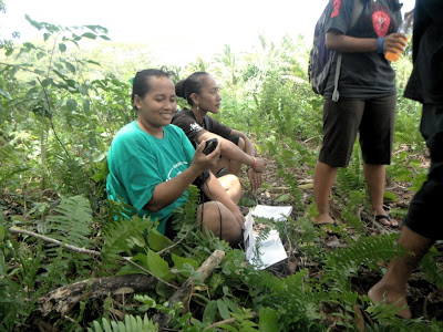
Maria-Asunsion checks her GPS readings.

The class listens as I use the day's experience to present the possible uses of GPS technologies. Maria-Asuncion, Reliann, Darla, Darby, Sepe Valton Palsis.
During Thursday's laboratory the class chased the answers to the related dual questions of how many meters per minute and how many meters is 0.001 minutes (the last digit of the GPS).

Reliann walks a line of latitude with the GPS. Chris Yamada, in the background, was the first to find me on Wednesday.

Sepe Valton Palsis and Jamori follow a line of latitude on Thursday.

Maria-Asunsion walks her line of latitude.

Notes from the board in the afternoon class.

Jaeger, in the 11:00 session, walks his line of latitude.

Frauleen studies her GPS.


Rickson with the GPS.

Science is fun! Person and Diana Pi'ilani.
The new laboratory design went well, although I need to get better at explaining why we generate three different experimental values for the meters per minute. I also was left wondering whether using the 1842 meters per minute value from WGS 84 as the "correct" answer is pedagogically valuable. That value appears like magic late in the laboratory and feels like it renders moot the data gathered. I think the surveyor's wheel can be treated as the "most accurate" value and that value used to determine the percentage error for the GPS unit average and Google Earth.
Some background on this laboratory and notes on its further evolution
The lab was rewritten in 2012 to focus measuring along a line of latitude. This was a return to a line of latitude, which was the original design circa 2007. Subsequently the lab shifted to walking on a line of longitude, south to north from A+ building and then generating a circumpolar distance with an error for the circumpolar distance. Ultimately multiple terms of refined guidance and explanation could not and did not make this make sense.
I abandoned the circumpolar focus and began using 071 hide and seek to draw attention to the differences in minutes displayed on the seven different GPS units that the class was using by 2012. This led naturally to the asked question, How far apart in meters is 0.001 minutes? This made a return to running a line of latitude make sense (I was no longer fixated on measuring the whole earth). But I was no longer wedded to the "maximum possible" walk that had the class walking from Burben to beyond the gym Spring 2013 I did a 127 meter lawn walk at 8:00 just north of the A and B buildings. At 11:00 I pushed back to the east and started from the sign. Crossing the ditch led to a maximal dist of 168 meters. Post lab I still got all kinds of confused lab reports. The lab was still not making sense. The three sets of of measurement being using were still confusing people. I realized I needed to get back to a single central measure, and that doing so would lead back to having a linear regression. Now Google Earth is the add-on that does not make sense, but I will kludge it on for now, the ruler just being a passing demo.
On Wednesday I hid at N 06° 54.604, E 158° 09.308'. The students picked up GPS units from Yolina this term.

My camera GPS recorded my location as N 06° 54.606, E 158° 09.317', the other Etrex units were in closer agreement to the Etrex Venture HC I used for the initial geolocation.

Senioreen checks to see if her GPS latitude and longitude agree with the handout. The lesson is really a discovery learning session where the students begin to learn to use a GPS and begin to get a physical familiarity with latitude and longitude.

Maria-Asunsion checks her GPS readings.

The class listens as I use the day's experience to present the possible uses of GPS technologies. Maria-Asuncion, Reliann, Darla, Darby, Sepe Valton Palsis.
During Thursday's laboratory the class chased the answers to the related dual questions of how many meters per minute and how many meters is 0.001 minutes (the last digit of the GPS).

Reliann walks a line of latitude with the GPS. Chris Yamada, in the background, was the first to find me on Wednesday.

Sepe Valton Palsis and Jamori follow a line of latitude on Thursday.

Maria-Asunsion walks her line of latitude.

Notes from the board in the afternoon class.

Jaeger, in the 11:00 session, walks his line of latitude.

Frauleen studies her GPS.

Darby and Beverly with their GPS. Senioreen in purple downslope, Mehrun on the right side is walking with Rickson.

Rickson with the GPS.

Science is fun! Person and Diana Pi'ilani.
The new laboratory design went well, although I need to get better at explaining why we generate three different experimental values for the meters per minute. I also was left wondering whether using the 1842 meters per minute value from WGS 84 as the "correct" answer is pedagogically valuable. That value appears like magic late in the laboratory and feels like it renders moot the data gathered. I think the surveyor's wheel can be treated as the "most accurate" value and that value used to determine the percentage error for the GPS unit average and Google Earth.
Some background on this laboratory and notes on its further evolution
The lab was rewritten in 2012 to focus measuring along a line of latitude. This was a return to a line of latitude, which was the original design circa 2007. Subsequently the lab shifted to walking on a line of longitude, south to north from A+ building and then generating a circumpolar distance with an error for the circumpolar distance. Ultimately multiple terms of refined guidance and explanation could not and did not make this make sense.
I abandoned the circumpolar focus and began using 071 hide and seek to draw attention to the differences in minutes displayed on the seven different GPS units that the class was using by 2012. This led naturally to the asked question, How far apart in meters is 0.001 minutes? This made a return to running a line of latitude make sense (I was no longer fixated on measuring the whole earth). But I was no longer wedded to the "maximum possible" walk that had the class walking from Burben to beyond the gym Spring 2013 I did a 127 meter lawn walk at 8:00 just north of the A and B buildings. At 11:00 I pushed back to the east and started from the sign. Crossing the ditch led to a maximal dist of 168 meters. Post lab I still got all kinds of confused lab reports. The lab was still not making sense. The three sets of of measurement being using were still confusing people. I realized I needed to get back to a single central measure, and that doing so would lead back to having a linear regression. Now Google Earth is the add-on that does not make sense, but I will kludge it on for now, the ruler just being a passing demo.


Dana. I was thinking of using the GPS devices for marking those grave yards in the Pohnpei State National Cemetery near the Mand Community area where now the Mand people utilize it since it is closer to our community. Reason for using it so we can mark the exact location where each family or community member was buried. It will goes along with a log to assist who has been buried there and when. Using the GPS can really pinpoint the exact location of the burial area for each person even if there are debris like grass has outgrown the tombstones. ONly a thought of mine for future generations. Thank you.
ReplyDelete